Stories
Peering Homeward, 1972
› Larger view
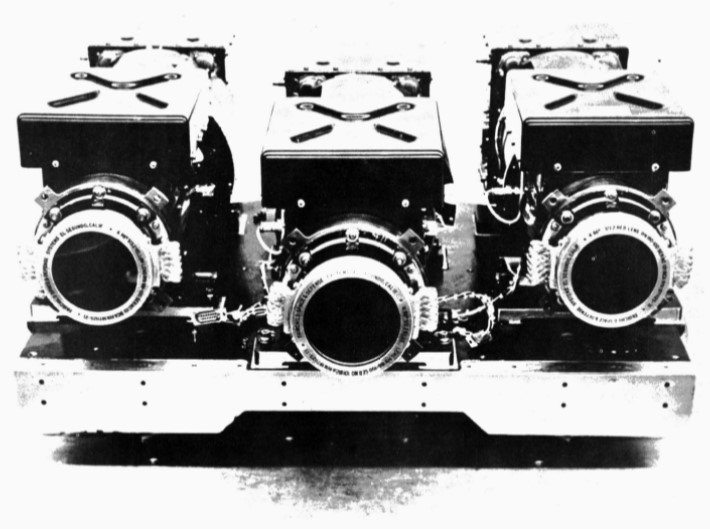
On July 23, 1972 the first civilian satellite designed to image Earth’s land surfaces was launched from Vandenberg Air Force Base in California. On board the satellite, originally named the Earth Resources Technology Satellite (ERTS), but later known as Landsat 1, were two sensors. The primary sensor, called the Return Beam Vidicon (RBV), used three shuttered cameras to take photographs; the secondary sensor, the Multispectral Scanner System (MSS) was an experimental instrument.
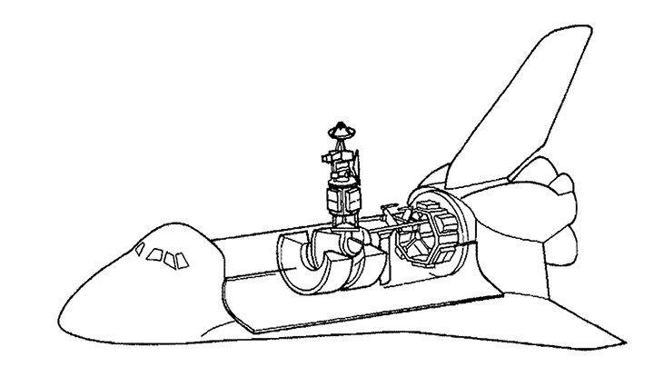
Both sensors were packed onto a “butterfly-shaped” spacecraft repurposed from the successful Nimbus weather missions. There were strict size and weight limitations for the sensors, especially the experimental MSS that weighed less than the primary RBV sensor and the data recorder. (At over 150 pounds, the data recording system onboard was the biggest recording device ever orbited.)
› Larger view
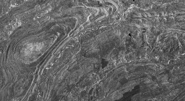
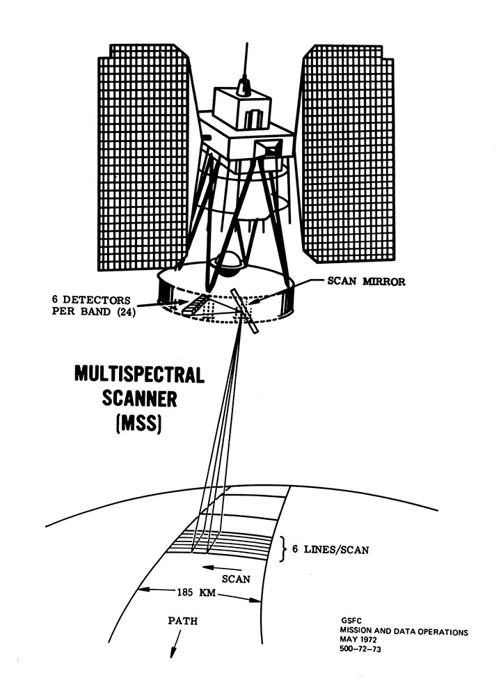
The MSS technology was a novel way of looking at Earth. It used a scanning mirror to build up an image pixel-by-pixel with six scan lines sweeping across the satellite’s ground path 13.62 times per second as the satellite hurtled around Earth at over 14,400 mph. As the first civilian imaging scanner to orbit Earth, many of the scientists and engineers outside the small cadre of scanner enthusiasts wondered if the satellite’s MSS instrument would be able to successfully produce an image traveling at such a high velocity. This made for a harrowing day when the first imagery was transmitted back to Earth two days after launch.
A group of Landsat scientists and engineers gathered in the Landsat data processing facility at NASA’s Goddard Space Flight Center as the first MSS digital transmission was translated onto 70-mm film by an electron beam recorder and then displayed. As they watched the first imagery scroll by they saw clouds, more clouds, and finally land… but the black and white image had irregular wavy lines on it.
“It’s terrible. It has moiré patterns,” a technician lamented. Quickly those in the room figured out where the image was showing geographically—the Ouachita Mountain region of southeastern Oklahoma. Then the geologists in the room realized that they were seeing the curvilinear outcrops of the ancient mountains.
› Larger view
Anxiety transformed into excitement. NASA geologist Nicholas Short, who had been unconvinced of the utility of land remote sensing for geology, turned to the NASA Deputy Associate Administrator for Space Applications and said, “I was so wrong about this. I’m not going to eat crow. Not big enough. I’m going to eat raven.”
USGS cartographer Alden Colvocoresses, who had been cynical about any cartographically accurate data being collected with “a little mirror in space,” turned to his colleagues in the room and said simply, “Gentlemen, that’s a map.”
To the surprise of many, it was the ride-along secondary instrument of Landsat 1, the experimental Multispectral Scanner System that became the mission’s imaging powerhouse.
The MSS instrument represented many “firsts.” It was the first space-based sensor to digitally encode and transmit Earth surface data; the first Earth-observing instrument to obtain in orbit calibration data, which meant it was the first instrument Earth-scientists could use to make robust comparisons of changes to Earth’s surface over time and across geographies. It quickly proved itself better than the primary Return Beam Vidicon instrument—and a good thing too because just 15 days after launch a major electrical short associated with the RBV’s power-switching circuit caused enough problems that the RBV was shut down for the rest of the satellite’s mission.
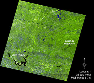
The MSS data’s accurate geometric fidelity made it a major cartographic tool, and the low sun angle of Landsat’s mid-morning acquisition time accentuated shadows of topographic features making the images especially valuable to geologists; but many fields including agriculture, forest management and marine studies found the data useful.
› Larger view
The Explorer 1 mission had begun the U.S. forays into space, yet a striking realization that came from the space-bound missions that followed Explorer 1 in quick succession (Mercury, Gemini, Apollo) was that space offered a distinctive vantage point for observing our home planet.
A few months prior to the Landsat 1 launch, Secretary of the Interior and Landsat champion, Stuart Udall, had explained to The New York Times, “I thought an Earth applications program was a perfect means of bringing the benefits of space back to Earth.”
Once Landsat and its MSS instrument had proved itself after launch, NASA Administrator James C. Fletcher confirmed Udall’s belief, remarking that Landsat was “a second giant stride for mankind” because of the new technology’s potential to improve the understanding of environmental issues. He went on to say that Landsat had a “profound effect on the thinking of the world, particularly on our approach to emerging problems of protecting our environment and maintaining the quality of life for all of Earth’s people…not just clean air and water, but clean land.”
The First Space-Based GPS Satellite Tracking Experiment, 1982
On July 16, 1982 the fourth Landsat satellite—carrying “the most complex and pioneering Earth viewing instrument ever proposed for a NASA program” at the time—took to the sky.
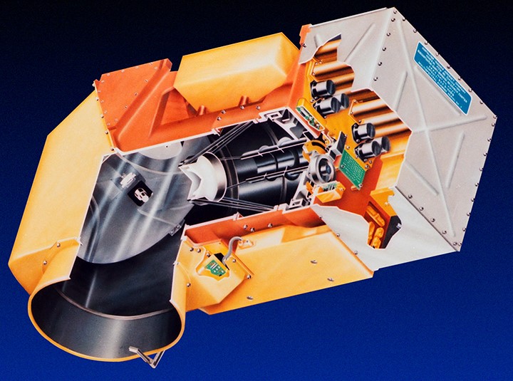
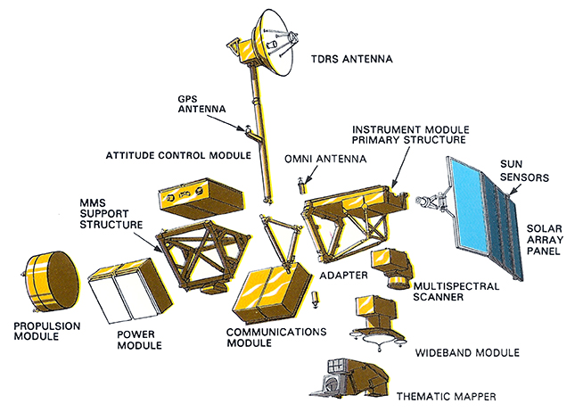
Nearly everything about this second-generation Earth observation satellite had been upgraded from its Landsat 1, 2, and 3 predecessors. In addition to an MSS sensor, Landsat 4 carried a second-generation Earth-observing sensor, called the Thematic Mapper or TM instrument. The TM, a more advanced version of the MSS, was only one aspect of the mission’s radical redesign.
› Larger view
The Landsat 4 spacecraft was a custom-designed platform and not a re-purposed Nimbus weather satellite platform used for the first three Landsats. But the mission requirements were many—the satellite was required to be Space Shuttle rendezvous ready (for the concept of Shuttle-based repairs); to carry a large antenna (at the end of a long 12.5 foot boom) for communicating with NASA’s Tracking and Data Relay Satellite System (TDRSS); and to carry a GPS receiver.
› Larger view
Landsat 4 was the very first civilian satellite to carry a spaceborne GPS receiver package and to use GPS signals to calculate its position. The concept of GPS was so new at this time that in Landsat 4 press communications, the acronym “GPS” had to be written out and described as “a new US Air Force satellite navigation system involving orbiting navigational satellites to triangulate the exact position of other satellites which require navigation information as part of their data communication to Earth Stations.”
GPS receivers were used on both Landsat 4 and 5 satellites to assess if GPS could deliver more accurate position-location data than data gathered from traditional methods (ground-predicted ephemeris, or mathematically modeled locations).
GPS was in its infancy and only 4 of the planned 24 GPS constellation satellites were in orbit at the time of Landsat 4’s launch. So there were often times during Landsat 4’s orbit when no GPS satellites were in range.
Two researchers at NASA’s Goddard Space Flight Center, Howard Heuberger and Leonard Church, presented a paper on the Landsat 4 GPS navigation results demonstrating that GPS could establish Landsat 4’s position to within 50 meters, and its velocity within six centimeters per second—when the GPS satellites were in view. Though these error margins grew exponentially when GPS satellites were out of reach (because of lapses between measurements), Heuberger and Church concluded that GPS was a good alternative for supplying onboard ephemeris to future spacecraft systems even before the full GPS constellation was in orbit.
› Larger view
The experiment was largely a success, but deemed not ready for operational use. It was not until the launch of Landsat 8 in 2013—almost three decades after the Landsat 4 GPS experiment—that GPS receivers would become a routine part of Landsat spacecraft.
For an exhaustive technical history of the Landsat program, see the new book: Landsat’s Enduring Legacy: Pioneering Global Land Observations from Space